Azores
The Azores Archipelago, located in the North Atlantic is made up of 9 islands divided into three geographic groups: The eastern group, composed of Santa Maria and São Miguel, the central group, which includes the islands of Terceira, Graciosa, São Jorge , Pico and Faial and the western group, made up of the islands of Corvo and Flores.
Located just 2 hours from Lisbon, these volcanic islands will enchant you with their authentic charm. Of a still preserved nature, the Azores offer you breathtaking landscapes. Whether by its volcanoes and green mountains alongside lakes of incredible beauty, by its superb waterfalls, by its roads lined with sumptuous walls of hydrangeas or by the typical vines growing in the middle of volcanic rocks whose color contrasts with the piercing blue of the Atlantic Ocean.
Composed of lush flora and impressive fauna, the Azores are an ideal destination for nature lovers.
Santa maria
Population: 5,636 | Area: 96.89 km2 | Main Village: Vila do Porto
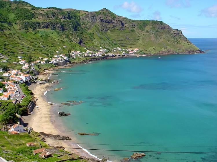
Baía de São Lourenço (Saint Lourenço Bay) is one of the most visited places in Santa Maria.
Santa Maria was the first island of the Azores to be discovered around 1427, by Portuguese navigator Diogo de Silves.
Later, in February 1493, Christopher Columbus climbed on the island on the return of his first trip to America.
The island’s main economic source is aeronautics, with Santa Maria Airport and the Atlantic Air Control Center, which manages the Santa Maria Oceanic FIR, one of the largest and most important flight information regions in the world.
Santa Maria is known for its clear sandy beaches (Formosa and São Lourenço) hidden by protected coves and abrupt cliffs.
Apart from the beach and the sun, as it is the southernmost island of the Azores, it is therefore the driest and the least rainy, and also sea sports such as surfing, windsurfing and sailing are always present, even due to the fact island be windy.
There are 6 walking trails on the island.
Some of the points of interest are: São Lourenço Bay, Lugar da Maia, Cascata do Aveiro, Poço da Predreira, Barreiro da Faneca, Baía dos Cabrestantes, and Ribeira do Maloás.
São Miguel
Population: 137 335 | Area: 744,7 km2 | Main City: Ponta Delgada
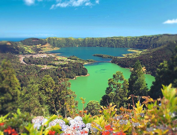
Lagoa das Sete Cidades. The green and blue lagoons, divided by a small bridge, are one of the archipelago’s most emblematic sights.
São Miguel is the largest island in the archipelago, 62.1 kilometers long and 15.8 kilometers wide.
It is the island that receives more tourists annually and has the largest number of infrastructures.
It is known as Green Island, for the predominance of colour green (Nature).
In São Miguel there are 29 walking trails.
The main tourist attractions are: Lagoa das Sete Cidades, Lagoa do Fogo and Furnas where you can try the famous stew (Cozido das Furnas; the ingredients are placed in a pan, which is placed and buried in the ground next to the Furnas boilers, with an average cooking time of five hours).
São Miguel is rich in viewpoints that offer magnificent views, the most important are: Boca do Inferno, and Vista do Rei.
On the island you can bathe in hot-water pools, either in Terra Nostra Park, with its unique Botanical Garden or at Dª Beija Swimming Pools. Also Ponta da Ferraria is a beach where a hot spring makes the sea water warmer than normal.
Terceira
Population: 55 377 | Area: 400,6 km2 | Main City: Angra do Heroísmo
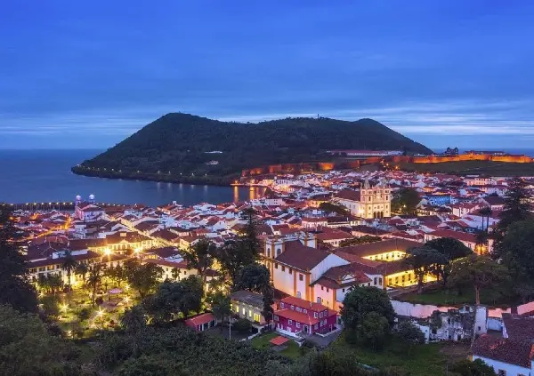
Angra do Heroísmo Historic City Center is listed as a World Heritage Site by UNESCO. Angra do Heroísmo it’s the oldest city on the Archipelago.
Terceira is the island with the greatest cultural and historical richness.
It is also known for the famous festivities. The Sanjoaninas festivities in Angra do Heroísmo and the Festas do Espirito Santo (Holy Spirit festivities) that last from May to October, make this island the one that celebrates the most.
The island offers 8 walking trails.
There are several important tourist attractions in the island, besides Angra do Heroísmo.
Serra do Cume Viewpoint (is one of the main viewpoints of Azores).
The caves: Algar do Carvão, Gruta do Natal and Gruta das Agulhas.
Furnas do Enxofre (Sulfur), Monte Brasil, and Serra de Santa Bárbara (the highest point of the island with 1021m, from where we can see the islands of S. Jorge and Pico).
Biscoitos (where you can visit the Wine Museum and bathe in the natural pools).
Graciosa
Population: 4 245 | Area: 61 km2 | Main Village: Santa Cruz
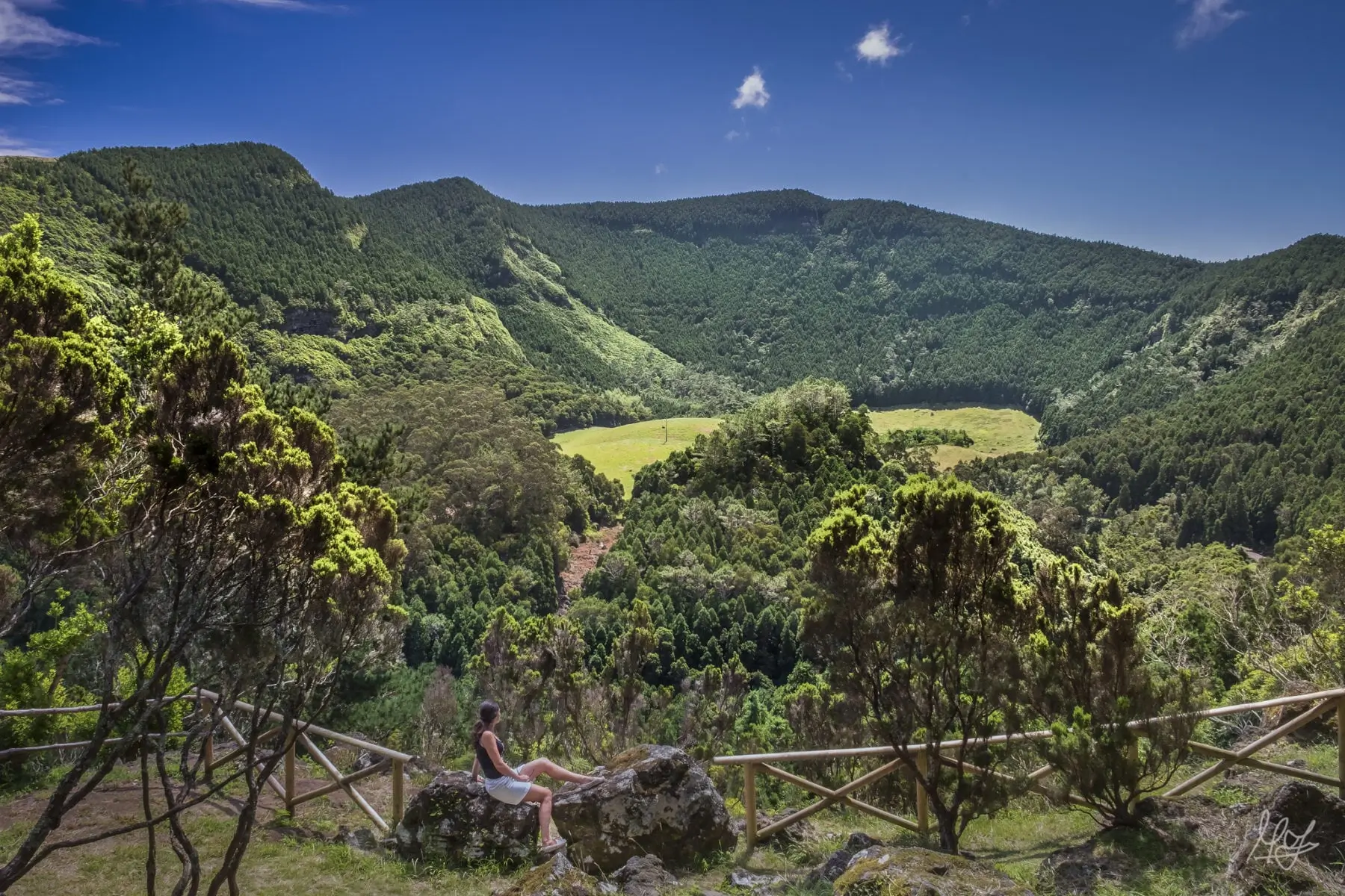
Caldeira da Graciosa, it is a crater of a volcano, and it is one of the most interesting place to visit in the Island.
Graciosa is the least mountainous of the Azorean islands, reaching a maximum altitude of 405 meters on the southern edge of Caldeira. This low elevation gives the island a temperate oceanic climate, characterized by the lesser rainfall of the archipelago.
The island offers 3 walking trails.
The most important points of the island in terms of tourism are Caldeira da Graciosa, classified by UNESCO as Biosphere Reserve.
The Caldeira da Graciosa Volcano also has volcanic manifestations such as the Furna do Enxofre fumaroles (a beautiful cave inside the Caldeira) and the Carapacho thermal springs (which have thermal waters at an average temperature of 40 degrees, which besides providing relaxation and well-being, have therapeutic and medicinal purposes) and the Baía dos Homiziados.
Santa Cruz, Folga and Praia bays are ideal places for activities such as windsurfing, rowing or sailing.
The Ponte da Barca Lighthouse viewpoint is one of the places to visit.
Porto Afonso is the favorite place for visitors to watch the sunset.
São Jorge
Population: 8 374 | Area: 233,5 km2 | Main Village: Velas
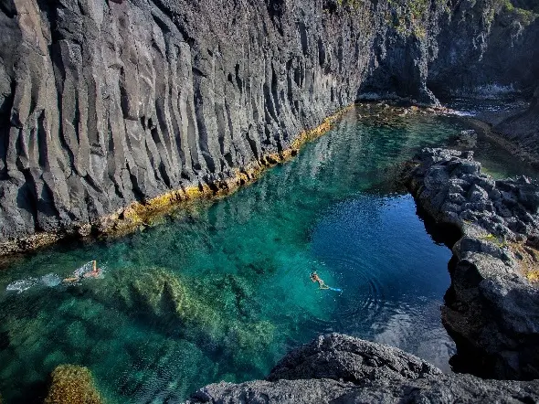
Simão Dias Natural Pool (Poça Simão Dias) is a natural pool. It is one of the most beautiful natural pools in the Azores.
The particularity of this island is the Fajãs, almost all inhabited but very difficult to access. On the north coast, there are Fajã do Ouvidor, Fajã da Caldeira de Cima, Fajã da Ribeira da Areia, Fajã dos Cubres and Fajã da Caldeira de Santo Cristo. On the south coast, the most important are Fajã dos Vimes and Fajã de São João.
The island offers 7 walking trails.
The most interesting points in S. Jorge, are undoubtedly the visit to the fajãs, either by way of a pedestrian trail, or by motorized transport (car, quad bike, all-terrain vehicle).
Other points to visit on the island are: Poça Simão Dias (one of the best natural swimming pools of Azores), Algar do Montoso Caves (a volcanic cave), Ponta dos Rosais (houses a large number of nesting seabirds), Ilhéu da Ponta do Topo (this islet is great for scuba diving), and Piscinas Naturais da Urzelina (natural swimming pool).
São Jorge produces the most famous product of the Azores, the Queijo São Jorge (the famous cheese). Visit Uniqueijo, in the municipality of Velas, to know the process of manufacturing this cheese.
Pico
Population: 13 688 | Area: 447 km2 | Main Village: Madalena
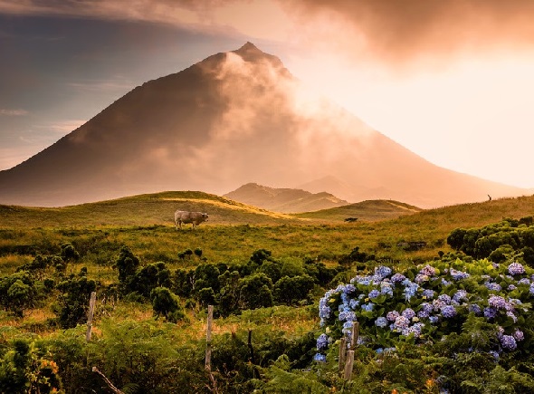
Pico Mountain is the icon of the island. The climb to this mountain with 2351 meters altitude is one of the main tourist attractions of the island.
Pico is the second largest island of the Azores archipelago. It has a unique natural habitat with caves, lagoons, seaports and natural pools.
Pico has 14 walking trails.
From its altitude of 2351 meters, the Pico mountain is the highest point in the Portuguese territory. From its magnificent summit we can admire the stunning view of the islands of Faial, Sao Jorge, Terceira and Graciosa.
The Azores archipelago is the largest cetacean sanctuary in the world! Pico has the best conditions to whale whatching in Azores. It is possible to see blue whales, sperm whales, dolphins, and others.
Other points of interest in Pico are: Gruta das Torres (the cave is of volcanic origin and is the largest lava tunnel of the archipelago), the UNESCO-protected Pico Vineyard Cultural Landscape, the various lagoons (Lagoa do Capitão, Lagoa Paúl, etc), the several Natural Pools, and the Museums (the Whaling Museum, the Whaling Industry Museum, the Wine Museum, and the House of Volcanoes).
Faial
Population: 14 591 | Area: 173,1 km2 | Main City: Horta
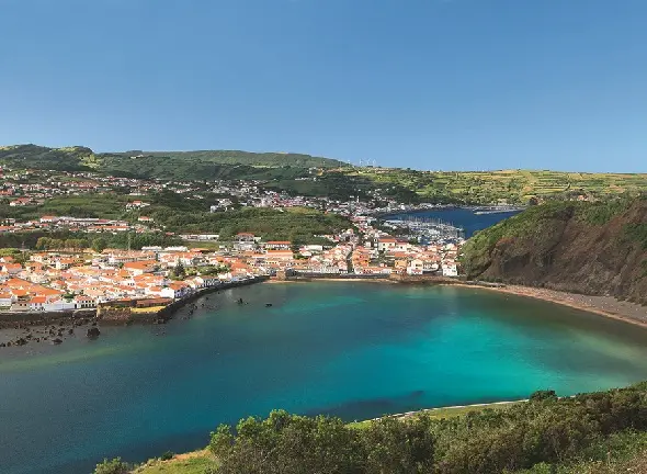
Baía do Porto Pim. Porto Pim bay was a whaling center from the late 18th century to the late 20th century.
The Port of Horta has been an important port for sea and air (seaplane) and submarine cable connections in the North Atlantic, maintaining a relevant activity as a commercial port and place of stopover of yachts in the crossings between the American continent and Europe. Faial Island is separated from Pico Island by an 8.3 km strait – the Faial Channel, making easy to go from one island to the other (30 minutes on boat).
Faial has 9 walking trails.
Faial’s Tourist Points of Interest:
Capelinhos Volcano was the last erupting volcano in the Azores between 1957 and 1958, having occurred at sea, near the Capelinhos islet. A visit to the Capelinhos Volcano site and the Centro de Interpretação do Vulcão dos Capelinhos is a must.
The city of Horta, its marina and Peter Café Sport are among the most visited places by tourists.
Porto Pim Beach (along with its Fort and Fábrica da Baleia), Almoxarife Beach (with the magnificent mountain view of Pico Island) and Praia do Norte are other areas to visit. The natural pools of Varadouro are one of the most interesting bathing areas of Faial.
Flores
Population: 3 646 | Area: 143 km2 | Main Village: Santa Cruz
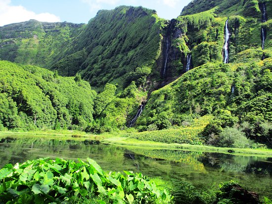
Poço da Ribeira do Ferreiro, also known as Poço da Alagoinha, is one of the most beautiful places with several waterfalls and lush vegetation.
Flores Island is considered to be the most westerly point in Europe, being part of the list of the UNESCO World Biosphere Reserve Network.
Being a small island and with few inhabitants is one of the best preserved and beautiful islands of the Azores.
There are 4 walking trails on the island.
Being a very humid island it is very rich in lagoons, waterfalls and vegetation.
Poço da Alagoinha are 20 waterfalls in the midst of the green of nature and the mountain. It’s a breathtaking beauty.
Lagoa Negra and Lagoa Comprida, are two pools side by side.
Poço do Bacalhau is a fantastic waterfall 90 meters high, and is also a place used for bathing, even if the water is very cold.
Reserva Natural das Caldeiras Funda e Rasa is a Portuguese Environmental Protection Area located on the Mosteiro site, and is formed by the Caldeira Funda Lagoon, the Caldeira Rasa Lagoon and the surrounding area.
The Rocha dos Bordões consists of huge basalt columns.
Corvo
Population: 464 | Area: 17,21 km2 | Main Village: Vila do Corvo
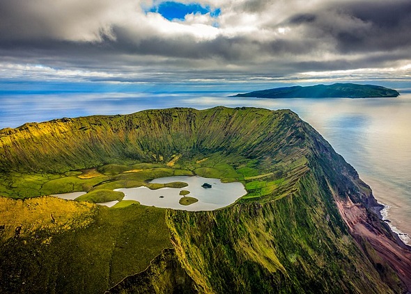
Aerial view of the Caldeirão do Corvo (volcanic crater). Lagoa do Caldeirão is the most important tourist spot of the island.
Corvo is the smallest of the islands of the Azores Archipelago.
With only 17km2 in area and about 300 inhabitants is considered as one of the most isolated areas in Europe.
Corvo Island is also on the list of the UNESCO World Biosphere Reserve Network.
There are 2 walking trails which are even more important on this island, whether due to its size, and the lack of transport that makes the simplest way to visit all the points of interest of Corvo by making the pedestrian trails. .
Points of interest:
Visit to the Caldeirão do Corvo and its lagoons. This is probably the most beautiful caldera of the Azorean islands. The Caldeirão do Corvo (volcanic crater) is “gigantic” and occupies almost half of the island. On clear days the landscape is overwhelming. The interior of the volcanic crater is partially occupied by lagoons and agricultural fields. The best way to visit is via the PR2 COR walking trail.
Praia da Areia, or Portinho da Areia, is a small dark sandy beach in the south of the island.
